Cultural Heritage Through Time (CHT2)
Developing products to visualise landscape change over time.
Diachronic landscape change studies are fundamental for documenting, maintaining and safeguarding all forms of cultural heritage in a sustainable manner.
“Cultural Heritage Through Time” (CHT2) was a European project, for which the scope was to develop time-varying 3D products, from landscape to architectural scale. It envisages and analyses lost scenarios or visualizes changes due to anthropic activities or intervention, pollution, wars, earthquakes or other natural hazards.

Project aims
The main project aims were:
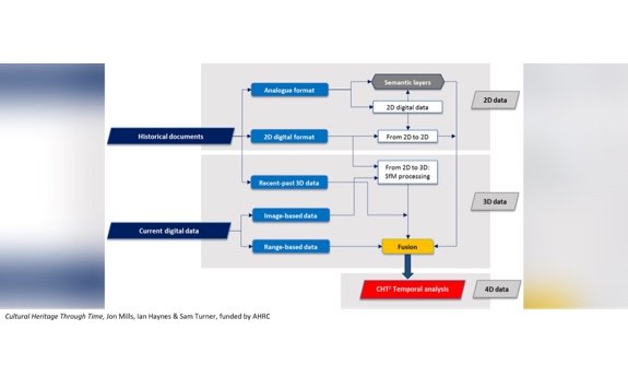
a) to generate 4D digital models of heritage sites, integrating heterogeneous data and expertise
b) to develop a methodology for future monitoring of heritage evolution (structures and landscapes) as a means of safeguarding
c) to share multi-temporal information via the internet (webGIS) for remote analyses and to disseminate culture, evolution and lost assets

The project included case studies in each of the four participating countries: the city centre of Milan, Italy; the fortress city of Krakow, Poland; the medieval walls of Avila, Spain; Hadrian’s Wall and its landscape, UK.
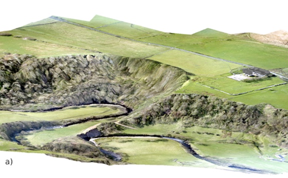
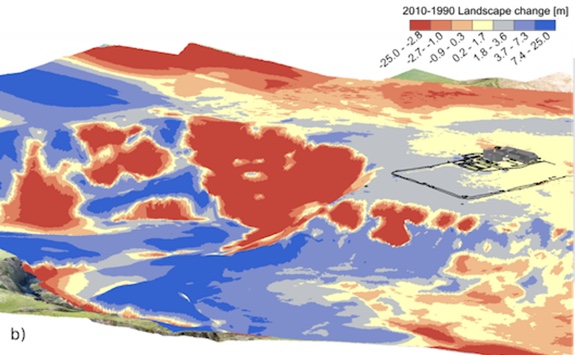
In the UK case study, particular emphasis was placed on aspects of landscape change caused by coastal, fluvial and soil erosion and its impact on cultural heritage with implications for historic site management, stakeholder interpretation and sustainable development.
Further information: Visit our official website for more information and a full list of publications.

Funder: UK Arts and Humanities Research Council (AHRC, award number AH/N504440/1); Joint Programming Initiative in Cultural Heritage (JPI-CH)
Duration: 1st September 2015 - 31 May 2018
PI and further team:
- Jon Mills - Civil and Geospatial Engineering, School of Engineering
- Ian Haynes - Archaeology, School of History, Classics and Archaeology
- Sam Turner - Director, McCord Centre for Landscape, School of History, Classics and Archaeology
Partners:
European partners:
- Politecnico di Milano
- Salamanca University
- Stanislaw Staszic Scientific Association
UK partners:
- Historic England
- English Heritage
Publications
Xiao, W., Mills, J., Guidi, G., Rodríguez-Gonzálvez, P., Gonizzi Barsanti, S. and Gonzalez-Aguilera, D., 2018. Geoinformatics for the conservation and promotion of cultural heritage in support of the UN Sustainable Development Goals. ISPRS Journal of Photogrammetry and Remote Sensing. In press.
OA Link: https://doi.org/10.1016/j.isprsjprs.2018.01.001
Fieber, K. D., Mills, J. P., Peppa, M. V., Haynes, I., Turner, S., Turner, A., Douglas, M. and Bryan, P. G., 2017. Cultural heritage through time: a case study at Hadrian’s Wall, United Kingdom. International Archives of Photogrammetry, Remote Sensing and Spatial Information Sciences, 42(2/W3): 297–302.
Rodríguez-Gonzálvez, P., Muñoz-Nieto, A. L., del Pozo, S., Sanchez-Aparicio, L. J., Gonzalez-Aguilera, D., Micoli, L., Gonizzi Barsanti, S., Guidi, G, Mills, J., Fieber, K, Haynes, I. and Hejmanowska, B., 2017. 4D reconstruction and visualization of cultural heritage: analyzing our legacy through time. International Archives of Photogrammetry, Remote Sensing and Spatial Information Sciences, 42(2/W3): 609–616.
.jpg)